
LANDSLIDE – ‘Worst-case scenarios’ contemplated on Chilcotin River
A flood warning, flood watches and an evacuation order remain in place due to a landslide over the Chilcotin River near Farwell Canyon.
The Province is continuing with around-the-clock monitoring in place and a risk assessment underway. Minister of Emergency Management Bowinn Ma said this afternoon (Aug. 2, 2024) that plans are in place for various possibilities.
“We continue to plan for worst-case scenarios,” said Ma.
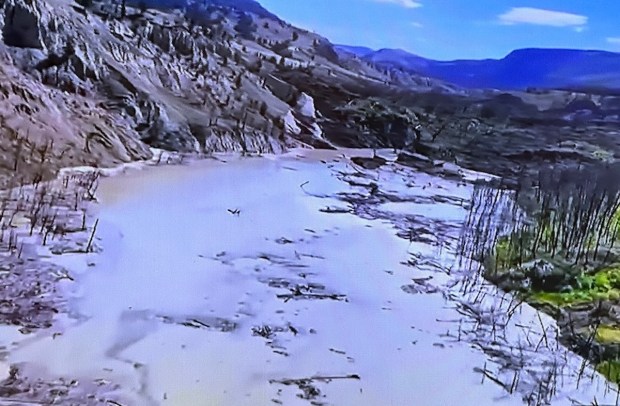
In the morning of Wednesday, July 31, 2024, a landslide blocked the Chilcotin River, which feeds into the Fraser River. The landslide is about 22 kilometres upstream from the Farwell Canyon Bridge and is estimated to be roughly 600 to 800 metres in length, 300 to 600 metres in width and 30 metres in depth.
The landslide has dammed the Chilcotin River and water is pooling behind the debris. It is estimated that the water has backed up behind the dam about eight kilometres up the river. The material blocking the river is composed of sands, silts and clays, which are susceptible to rapid erosion.
Provincial personnel are assessing and monitoring the landslide with modelling and mapping, geotechnical assessments, remote sensing technology, Light Detection And Ranging Data (LiDar) and environmental impact assessments.
The focus is on learning as much as possible about when and how the water is most likely to be dispersed to the Chilcotin River. The latest word from Ma on that today is that it might surge over the top of the slide rather than breach through it.
While it’s expected the river could break through the slide within the next couple of days, there’s no firm timeline on when that may occur. Personnel are monitoring the site 24/7. Drones and aerial resources are also being used for monitoring.
It is possible a large amount of debris will flow down the Chilcotin River to the Fraser River confluence, then south to Hope and ultimately to the ocean. However, even if a rapid surge were to happen at the landslide site, it’s expected to take a number of hours for the debris and increased water levels to make it down the river to the vicinity of Hope. Ma said today it may take 12 to 24 hours.
The Province is continuing to co-ordinate with local authorities, First Nations and the federal government.
BC Emergency Alerts have been issued via cellphones, radio and television to people near the area. The Cariboo Regional District has an active evacuation order in place for areas surrounding the landslide. The Province may issue further BC Emergency Alerts as needed. For more information on active evacuation alerts and evacuation orders, visit: https://www.emergencyinfobc.gov.bc.ca/
Ma urged people to avoid the Chilcotin River and the Fraser River from Hope to the Chilcotin River confluence. People living in areas where a flood warning, flood watches and high streamflow advisory have been issued are encouraged to pack a grab-and-go bag and have an evacuation plan ready in case they are required to evacuate.
Evacuation reception centres are being readied as a precaution, and sandbags, sandbag machines, gabions and tiger dams are ready to be deployed to communities if needed.

It is best to build a ditch starting at the downstream edge of the slide by excavating or blasting toward the upstream edge. Create a dam with locks or controls before accessing the water. This allows control of the water exit from the new lake. This lake will continue building until it cuts through and begins to erode out of control creating flooding and destruction downstream. This must be done FAST.
LikeLike