
Youds — Cool, gorgeous Mara Canyon needs some work
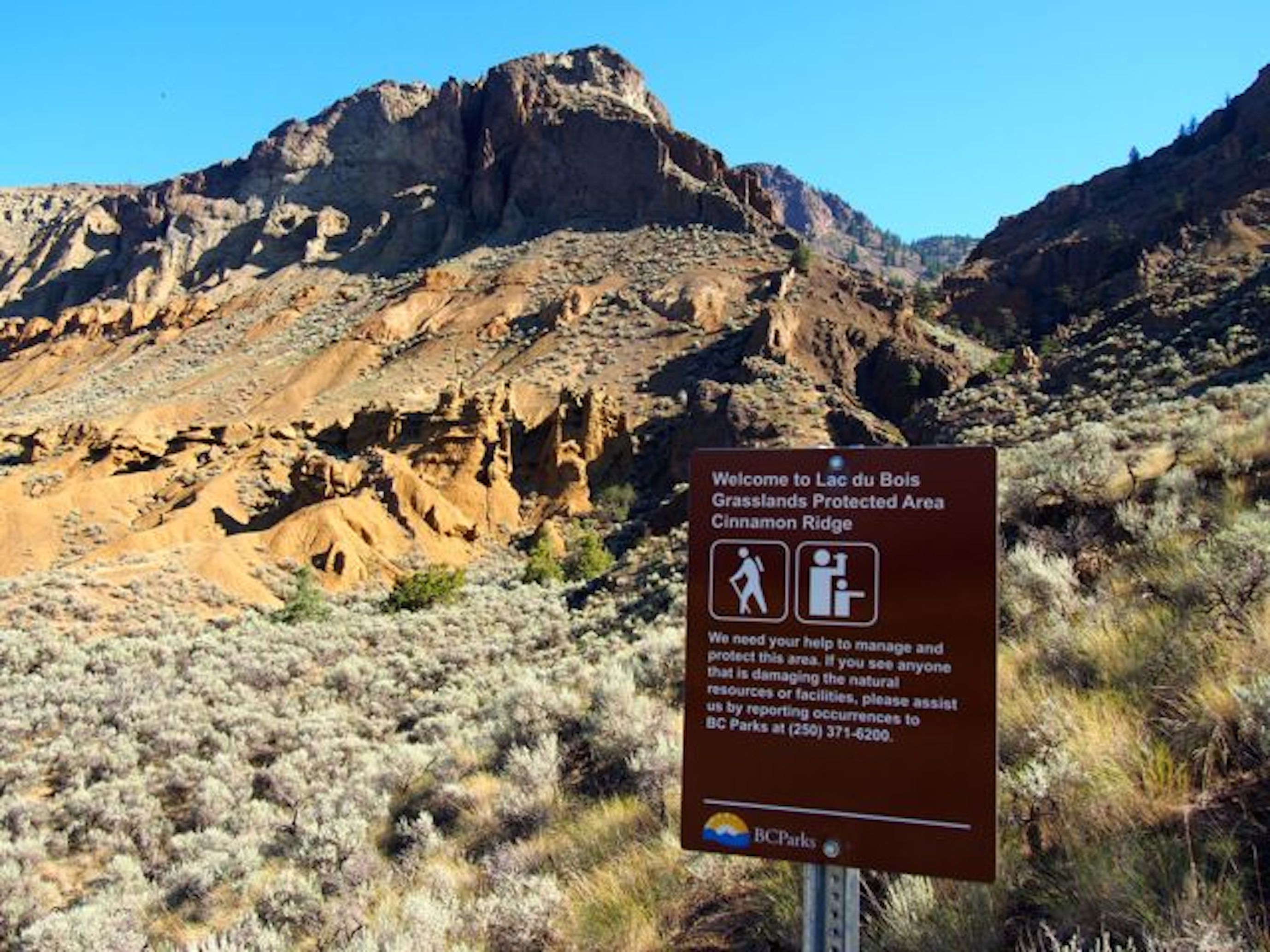
The lonely B.C. Parks sign at Mara Canyon trailhead.
COLUMN — Mara Canyon could have been deadly last Wednesday afternoon.
Just 15 minutes from downtown Kamloops, you can descend within a couple of minutes from sagebrush and silt bluffs deposited by Greater Lake Thompson into a different ecosystem, lush with vegetation, sheltered from desert extremes, affording spectacular views of coppery bluffs high above and dotted with hoodoos reminiscent of the work of Antonio Gaudi, the one the Spaniards called “God’s architect.” Entering the canyon is a little like going down the rabbit hole.
 Coincidentally, the Spanish word “canon,” meaning pipe, gave us the English word “canyon.” The terms gorge and canyon are used interchangeably, but a gorge is almost always narrower and deeper than a canyon, according to National Geographic.
Known locally as Cinnamon Ridge, between Brocklehurst and Tranquille above the municipal composting facility, the ridge is a mountainous nub of Lac du Bois Grasslands Protected Area, though you’d hardly know it holds any special status when you’re there.
After last week’s “weather event” (loose translation: “We’re not sure if it is the new normal”), which dropped 25 mm in 25 minutes, I thought I’d revisit the ridge. Mara is an all-season destination, often dry and barren of snow in the winter yet cool in the summer, at least in the canyon. More than a week after the flash flood, water was still trickling down its boulder-strewn bottom, where it was about 15 degrees cooler than on the ridge above.
This was not the same picture of tranquility last Wednesday. As a Sun Rivers resident pointed out, the Kamloops flash flood would be considered routine in the U.S. southwest. There, you might be hiking a dry desert gorge on a crystal-clear sunny day and suddenly drown in a wall of water.
Like other valley wall formations between Kamloops and Pritchard, the box canyon that cleaves the base of Mount Mara owes its existence to the power of water over the past 12,000 years. Yet these cathedral spires weren’t shaped by slow trickles; this is the land that flash floods sculpted in violent bursts of energy. Why not see if nature had reworked the subject to a degree possibly unseen for a century or more?
Although part of Lac du Bois Provincial Park, Cinnamon Ridge has come to represent a delicate compromise from a management standpoint. This is obvious when you clamber up a plume of loose gravel past a barbed wire fence and over twin rail tracks to get to the trailhead, not exactly welcoming signs for visitors from afar. There is only one lonely sign at the foot of the canyon, urging visitors to respect the park and “facilities,” facilities that don’t exist. The trail can be hard to pick up unless you know it’s there. And sometimes it’s not there anymore.
As a B.C. Parks official once explained, this ambiguous state of affairs exists because they want to accommodate recreational users without encouraging greater numbers on Cinnamon Ridge. The loose, vertical terrain is vulnerable to heavy foot traffic and the access point over the tracks can’t be officially sanctioned, obviously. Still, there are often half a dozen vehicles at the trailhead on Tranquille Road most weekends and hundreds of people enter the park there each year.
There used to be one section, not far from the start of the canyon trail, where it narrowed to a passageway, leaving barely enough space to squeeze through without turning sideways. That section is now considerably widened by the flood. A massive wave must have come down the mountain, blowing out the gorge walls. (Fortunately, a hiker at this spot last week would have been tipped off by the exceptionally heavy rain and headed for higher ground.)
Elsewhere along the route, the flood simply rearranged the furniture. One more dead pine is down. Pines that were already down are now further down the gorge. Several sections of the trail are washed away, posing new hazards, but that’s the nature of hiking in a flash-flood gorge, isn’t it? Hiking Mara gorge was always a bit like cross-training — scramble, scale, jump. It’s not a safe trail for inexperienced hikers and probably less so after the storm. Hard-soled boots with good tread are mandatory to grip pea gravel on hardpan. On the descent, it’s sometimes like walking downhill on marbles, so carry a hiking pole to prevent injuries.
What draws me back, aside from readily accessible rugged beauty, is variety. You can do a short walk to the foot of the canyon, a two-hour canyon return hike or a three- to four-hour summit hike to the top of the mountain, returning via a circle route down the ridge, plus there are lesser routes along the way. If it’s a frosty February, take the sun-exposed ridge; if it’s cooking hot in July, cool off in the canyon.
Many of us love this area, but we don’t want to love it to death. Trail improvements would go a long way to preserving the landforms that make it a special place. Kamloops-Thompson Trails Alliance also values Mara’s attributes and knows its recreational importance to locals. They’ve flagged it for badly needed trail improvements, but it’s been on hold indefinitely until trail access has been resolved. There is an alternative access point two kilometres distant, where the Mount Mara trailhead lies, but that would add four kilometres of walking.
“We’ve been told (by Parks) that there are things they need to work through before we do any work,” said Richard Doucette, president of the trail alliance. He realizes that any trail-building in that terrain would be a challenge, particularly through the canyon. In the meantime, the alliance has plenty of projects on their hands, including major work at Isobel Lake over the next couple seasons. (And they welcome new volunteers.)
There is some promise on the horizon for Cinnamon Ridge. An updated draft management plan for the park is to be vetted for public comment, possibly later this year. That will be the first update after a decade of change for Lac du Bois Grasslands Protected Area. Considering how important these lands are on so many levels, the surrounding community will want to note that on the calendar.
Remember, as well — if you happen to be hiking a desert gorge in a heavy rainstorm — to get the hell out of there.
Mike Youds is a Kamloops journalist who writes for The Armchair Mayor News.

Thanks, Armchair, for the response. So the name actually goes back to the 1800s. I had been thinking that it was named after John and Rose Mara. of Multicultural fame.
LikeLike
I did not know Mike Youds could write like this! Armchair, you have given him his freedom! This article and the mountain bike one are brilliant. Looking forward to more!
LikeLike
Nice article. Won’t get any response to the following question, but here goes anyway: Who are Mara Canyon and Mount Mara named after?
LikeLike
I’m just guessing, but John Andrew Mara, a wealthy Kamloops merchant and politician from the 1860s to 1880s?
LikeLike