
UPDATE — More rain on way as city deals with aftermath of powerful thunder storm


UPDATE (Thursday 6:20 a.m.) — more rain fell overnight and there’s more on the way today but there won’t be another deluge like the one experienced in Kamloops and other regions of the Interior on Wednesday, says Environment Canada.
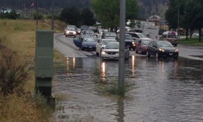
Twenty mm of rain fell within about 20 to 30 minutes Wednesday afternoon, drenching the City and causing widespread flash flooding and damage.
Power outages were widespread and B.C. Hydro is still dealing with close to 2,400 outages in the Thompson Shuswap and another 4,300 in the Okanagan-Kootenay region.
Today (Friday) should be another cloudy and rainy day with about 10mm of rain and winds to 20 km/h. The high will reach only 20C. Showers will begin this morning and end in the afternoon. Tonight will be partly cloudy.
The good news is that the sun will return Friday, sort of. A mix of sun and cloud still holds a 30 per chance of showers but starting Saturday we’re in for several sunny days again.
Kamloops residents will be kept busy telling war stories about the outage today — tales of walking in water up to their knees, bailing out basements, escaping the torrent that was roaring down hills, plugged storm sewers, blown-out manhole covers, or being stranded in their vehicles.
Bill Hadgkiss was volunteering at an Interior Car Share booth in the Downtown Merchants Market Wednesday afternoon when it hit so fast no one had a chance to prepare for it.
“It was blowing tents across the street,” said Hadgkiss. It was like having a shower outside, he said.
Car Share volunteers managed to collect up their materials and take shelter in the lobby of John DeCicco’s barbershop to sort things out, but that ended any thoughts of anything but finding a ride home.
UPDATE (Wednesday afternoon)
By MICHELE YOUNG
A sudden and intense thunderstorm Wednesday has caused widespread flooding in Kamloops, leaving City staff scrambling to deal with an onslaught of calls for assistance.
City utilities director Jenn Fretz said the storm was unusual in that there are normally pockets or localized areas of flooding. But Wednesday’s deluge hit the entire city.
“We’ve been flooded with calls,” she said just before meeting with City fire officials to sort out priorities for the resources available.
“We’ve got everything we possibly can out there with regard to boots on the ground,” she said.
“We’re trying to prioritize resources right now.”
Even as this update is being posted at 4:20 p.m., more rain is coming down.
In addition to the usual places that flood when the rain pours down, such as the 10th Avenue underpass, the storm also popped out manhole covers throughout the city.
At the Kamloops airport, one WestJet flight was delayed and an Air Canada flight inbound from Calgary had to hold off from landing while the storm passed over.
Operations manager Ed Ratuski said the storm meant shutting everything down for about 20 minutes as lightning zapped through the area.
“We had to shut down the ramp for about 20 minutes as part of our safety precautions if the lightning is within the zone. We got lots of lightning,” he said.
There were no reports of lightning striking anything.
The post-storm lull won’t last long. Environment Canada meteorologist John McIntyre said the storm came, dumped and has moved eastward to the Okanagan Valley. But Kamloops will be getting a steady rain that could add 10 to 20 centimetres to the flooding and puddles that the storm left behind.
That said, at least the rain will happen over several hours, not several minutes, he said.
“This was a pretty strong front that moved up from south to north in the afternoon. It caused severe thunderstorms throughout the Thompson and right into Kamloops,” said McIntyre.
“There are going to be significant amounts of rain tonight coming in from the northeast. . . . It could be another 10 to 20 centimetres.”
As City staff began mopping up after the storm blew through, Fretz advised residents to be patient and report any problems to the public works hotline at 250-828-3461.
NEWS — Widespread localized flooding is being reported around Kamloops in the wake of a giant thunderstorm that passed through city like a tsunami and headed up the North Thompson Valley, bringing thunder, lightning, wind and hail.
The brunt of the storm only lasted about 10 minutes but it was a humdinger.
Twitter photo.
Tweeters captured much of it, sending out photos of flash flooding on Laval, the Summit and Notre Dame intersection and other areas. One showed children in kayaks after the storm passed.
Kamloops RCMP have been kept busy responding to numerous incidents throughout the afternoon as a result of heavy rainfall that came with the storm beginning around 2 p.m.
The south end of the Overlander Bridge was reduced to one lane of traffic southbound, due to debris falling on the roadway from the runoff up above.
A slide has come down on Highway 5 in the northbound lane between Sun Rivers and Mt. Paul Way, reducing northbound traffic to single lane.
Cpl. Cheryl Bush said the third area of concern is the 10th Avenue underpass at Lorne Street, where water has accumulated and trapped one motorist on the roof of their vehicle due to the high water.
Police have asked motorists to avoid these particular areas until the water has time to recede and crews have time to clear the roadways.
https://twitter.com/ClayChimera/status/492162696368750593

It happens every year and the forecasters did warn us it was coming. Can we be better prepared? Can the city, in their infinite wisdom (or lack of thereof) be better prepared?
On these matters a wise guy once told me “think like a mountain”. How clever!
LikeLike
had a hard time seeing our next neighbour’s house, which is 25 feet away. Well the city should be happy that the residents will not have to water their collective lawns for a few days. Hope everybody and their property is secure.
LikeLike